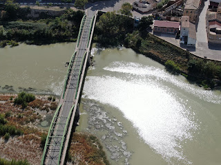
A good example of sun glitter while the drone raises and films oriented towards the sun, however it can be helpful to determine a correlation between surface reflectance and roughness, and related flow speed.
Drones make easier to recognize surface speed patterns and debris storage areas in order to clean up plastic litter , as this image of Alcala de Ebro groynes shows. See more at The Ocean Clean Up project and https://doi.org/10.3390/rs11172045
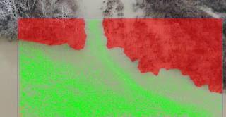
This is a particular village 30 Kms upstream Saragosse along the Ebro river, Google-Map , where we can observe a riverine island with its typical confluence pattern, and our computer LSPIV video processing:
Shallow flows with relatively transparent water, captured by 4K camera drones and filtered by computer, can help to define the bathymetry without more expensive data acquisition. See this example nearby "Sotos del Ebro, Alfaro".
Tests at Castejon de Ebro: Checking heights for look angles, fields of view and resulting flow resolution around Castejon railway bridge, during the dry season . This is a key reach for monitoring the Ebro river during flood periods.
State of the art technique is available at this IAHR publication: https://iahr.org/Portal/News/News%20-%20Latest%20issue%20of%20Hydrolink%20on%20Drone%20Special%20is%20now%20published.aspx
4K images dozen of meters above water surface allow for tracking the flow speed in this confluence, the change in velocity determines the driving forces (Newton´s 2nd Law) and the prediction of effects and control measurements. Drone videos and further image processing are affordable tools for real scale studies.